The maps in this website
 Maps are useful tools in the building of our historical knowledge about societies and peoples, giving us information about the relative locations and physical environments where historical events occurred. Two types of maps are reproduced in this platform, ancient maps and didactic maps. Old maps give us, even if in a partial manner, a sense of the geographical knowledge shared by those mapmakers who made them and those who used them at the time they were made, including rulers and government officials controlling or interested in the territories depicted, military officers under the orders of a government, or merchants and travelers.
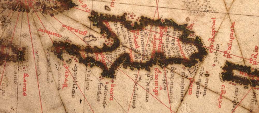
Very few maps of the island of La Española made in the sixteenth century have survived, giving us an incomplete picture of how the cartographers saw or interpreted the island’s territorial and population settlement features at the time. Didactic or illustrative maps, based on the standard or prevailing contemporary geographical knowledge and depictions of La Española are intended to help us connect the historical data presented here about the early Black inhabitants with the specific known places and physical landscapes of the island. (To access an image gallery of maps of sixteenth-century La Española contained in this platform, please click here or go to the "Resources" section of the main menu bar and click on "Maps.")
The CUNY DSI has obtained authorization to reproduce in First Blacks in the Americas some of the existing maps made in the 1500s of La Española and the surrounding territories of the Americas, and they are showcased throughout different sections of the platform at the highest resolution possible, so that visitors to this site may access the information contained in them with as much thoroughness and accuracy as possible. One of the interesting features of these maps are the toponyms or names of places and landscape features, which allow us to identify place names that in many instances have survived or evolved during more than five hundred years of history into today’s geographical nomenclature in the Dominican Republic and the Republic of Haiti, while others passed into oblivion.
Re-publication or public reproduction of the maps presented in First Blacks in the Americas require permission from the institutions that currently hold the originals and have granted CUNY DSI authorization to reproduce them exclusively in this educational platform.